
Understanding Recent Seismic Events
In recent months, the world has witnessed several notable seismic events, including magnitude 7 or higher earthquakes in Indonesia, Colombia, and Mexico, leading to fatalities. Additionally, two powerful quakes in Venezuela in June caused widespread devastation. These occurrences often lead to public inquiry regarding an apparent increase in earthquake frequency. To address this, it's essential to examine long-term data and understand the mechanisms behind earthquakes.
Analyzing Global Earthquake Data
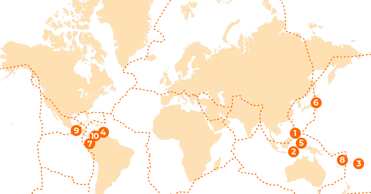
The United States Geological Survey (USGS) estimates approximately 20,000 earthquakes occur globally each year, averaging around 55 daily. The majority of these are imperceptible to humans. Earthquakes typically begin to cause significant damage at magnitudes of 6 or higher. In 2026, the ten largest earthquakes included a magnitude 7.8 event off Mindanao in the Philippines, which resulted in over 100 deaths. Venezuela experienced 7.2 and 7.5 magnitude quakes, causing over 6,300 fatalities. More recent quakes in Mexico (July) and Colombia and Indonesia (August) all registered 7.4 magnitude or higher.
A review of earthquake data from 2016 to 2025 reveals an annual average of 133 earthquakes with a magnitude of 6 or greater. The lowest count in this period was 99 in 2024, while the highest was 157 in 2021. As of mid-August 2026, 91 earthquakes of magnitude 6 or above had been recorded globally, with 11 exceeding magnitude 7. While these figures are slightly above the average pace of the last decade, they remain within the expected statistical range. Importantly, no earthquakes reached magnitudes 8 or 9, which are the most destructive categories.
The lethality of an earthquake is often less dependent on its magnitude and more on factors such as its depth, proximity to urban centers, and the structural integrity of local buildings. Historically, the deadliest earthquakes have not always been the largest in magnitude but rather those that strike beneath densely populated areas.
dispelling myths: Earthquake seasonality and predictability
There is no scientific basis for an 'earthquake season.' Historical records demonstrate that earthquakes occur throughout the year without any consistent seasonal pattern. Seismologists have not been able to predict the exact timing of major earthquakes because the tectonic stress accumulating along fault lines over decades or centuries cannot be linked to a 12-month cycle. While aftershocks can persist for months or even years following a major quake, the focus of modern seismology is on calculating the probability of a large earthquake in a given area over several years. This probabilistic approach informs crucial building codes and underpins early warning systems that activate once an earthquake has commenced. Seismologists analyze seismograms to quickly determine an earthquake's location, depth, magnitude, and fault movement.
The Mechanics of Earthquakes
An earthquake fundamentally occurs when the Earth's crust experiences shaking. The Earth's outer layer is composed of approximately 100km-thick tectonic plates that fit together like a puzzle. These plates rest upon a hot, solid yet slowly flowing mantle rock, which facilitates their movement over millions of years. Although the plates are in constant motion, their edges frequently become locked, leading to a build-up of stress. This stress is eventually released when the rock fractures along fault lines, which can extend for hundreds of kilometers. While many faults are well-documented, others are only discovered when they rupture.
Global Seismic Hotspots
The most seismically active region globally is the Pacific Ring of Fire, which accounts for approximately 90 percent of the world's earthquakes. This belt stretches along the western Americas, extends to the Russian Far East, and continues through Southeast Asia to New Zealand, encompassing nations like Japan, the Philippines, and Indonesia. Beyond the Ring of Fire, the Alpide belt, which spans from Java through the Himalayas to Turkey and the Mediterranean, generates about 17 percent of the world's largest earthquakes. Rarer tremors can also occur along ancient faults far from active plate boundaries.
Measuring Earthquake Intensity
Earthquake size is quantified using the moment magnitude scale, which reflects the energy released at the earthquake's source. This scale is logarithmic, meaning each whole-number increase signifies roughly a tenfold increase in ground shaking and approximately 32 times more energy released. For instance, earthquakes between magnitude 4 and 4.9 are considered light but can still cause some damage. A magnitude 5 quake generates ten times more ground shaking than a magnitude 4 and releases about 32 times more energy, potentially causing moderate structural damage. Magnitude 6 quakes are generally classified as strong, producing 100 times more ground shaking than a magnitude 4 and releasing about 1,000 times more energy. Major earthquakes, registering at magnitude 7, have the potential for significant casualties and extensive damage to infrastructure. Earthquakes of magnitude 8 or higher are termed 'great' and can lead to near-total destruction across broad regions. The overall impact and deadliness of an earthquake are determined by a complex interplay of factors, including magnitude, depth, proximity to populated areas, soil conditions, and the potential to trigger secondary disasters such as tsunamis and landslides.
Historically Significant Earthquakes
The most powerful earthquake ever recorded was a magnitude 9.5 event in Valdivia, Chile, on May 22, 1960, which generated a Pacific-wide tsunami. The second most powerful was a magnitude 9.2 quake in Alaska's Prince William Sound region four years later. On December 26, 2004, a magnitude 9.1 to 9.3 earthquake off the coast of Sumatra triggered a devastating tsunami that claimed approximately 228,000 lives across the Indian Ocean region.